The QUaD Telescope, Part 1: Purpose
I have already briefly mentioned that I am at the South Pole right now in order work on a telescope and that this telescope has something to do with measuring microwave radiation. So, let me be a little more detailed in explaining both the purpose of the telescope and how it works. In future posts, I’ll detail my purpose here and how I work too, but let’s save that until later. In the following, I am taking many liberties with my use of technical jargon and being somewhat sloppy with detail. I’m doing this to paint as simple a picture as I can and reach as many people as possible. If there are any strong objections to any statements here, let me know and I’ll try to fix them.
Why microwaves?
First, microwave radiation should be familiar to you if you have microwave oven. Microwave radiation is very similar to radio waves in frequency and wavelength, so you are even familiar in detecting them if you have ever had to adjust your radio to a certain station or move the antenna to get better reception. In fact, your cell phone uses microwaves in order to send or receive phone calls! Yet, cell phones, ovens and radio stations are not the only sources of this radiation. Nearly everything that has any energy gives off some radiation, and the hotter the object, the more and the more energetic the radiation. For example, your 100 degree Fahrenheit body (roughly 40 degrees Celsius) gives off quite a bit of infrared light (so red you can’t see it) while the Sun at roughly 6,000 degrees Celsius gives off yellow/green light. Well, you and the sun, the atmosphere and even the snowy ground here give off microwaves, which are “redder” than infrared light.
There are many reasons one might want to study microwave radiation. Stars, gas and dust in the Milky Way Galaxy give off plenty of microwaves. In fact, some galaxies like those with super-massive black holes in their centers, give off huge quantities of microwaves. QUaD isn’t interested in these astrophysical microwave sources. The source QUaD is interested in is the whole universe itself. These microwaves are the remaining radiation from the ancient universe. Big bang theory, the basis of modern cosmology or the history of the universe, claims that once the universe was very dense and hot and then expanded until now. That means everything was squished together much closer than now. When you squeeze something together, it heats up and 13 billion years ago the young universe was very hot indeed.
In fact it was so hot and dense that it wasn’t filled with stars and galaxies spread out like they are now but instead a thick gas, in some ways like the air you breathe (for analogy) spread out all over the place, everywhere. This hot gas that filled the whole universe shone very brightly. That light traveled through space and time and continues to do so now. Yet, as it traveled the universe also stretched out causing this hot bright radiation to “cool” down to microwaves. Now, since this is radiation that originated from a continuously spread out gas, it should be coming from everywhere at once. This is exactly what we see when we look out into space; in every direction we see the same microwave radiation all with the same temperature. This radiation fills the universe, like a bath, like a microwave oven. It passes through you and me and everything around us. The microwave radiation is commonly called the Cosmic Microwave Background (CMB). This is because it fills the universe and exists as a background temperature bath.
So, if the radiation is uniform and all around us, what else is there to learn?
Ok, the thing is that if the universe were once perfectly smooth, with no bumps and all at the same temperature, it wouldn’t ever clump up. If it was so smooth, there would be an equal pull from all directions on any patch of it and the net result would be that the patch wouldn’t go anywhere. Well, that’s obviously not true, there are tons of clumps all over the place. There are millions of stars in each galaxy, and billions of galaxies in the universe, and even the galaxies tend to clump up into groups. Where did all the clumps come from? Well, that’s a very difficult question to answer and the current answer lies in the theory of inflation, which I don’t want to talk about here and now. Inflation tells us a way to make the clumps. Inflation is a special case of universal expansion, one that last a very short time, is very intense and happened very early on in time.
So, if the clumps are there even in the early universe, then we should see clumpy parts that look a little hotter than less clumpy parts; remember the denser the hotter so clumpy parts will be hotter. This means that while the microwave radiation is mostly smooth and the same temp, if you look really carefully you should see some parts hotter than others. Well, guess what, we do. The CMB was discovered nearly 50 years ago, the clumpiness about 30, the details of the clumps were worked out by 10 years ago. Now, the CMB is some of our best evidence for big bang theory and universal expansion. Well, we can see the expansion of the universe by looking at galaxies; the CMB was a PREDICTION or CONSEQUENCE of expansion and big bang theory. Its discovery was a great affirmation.
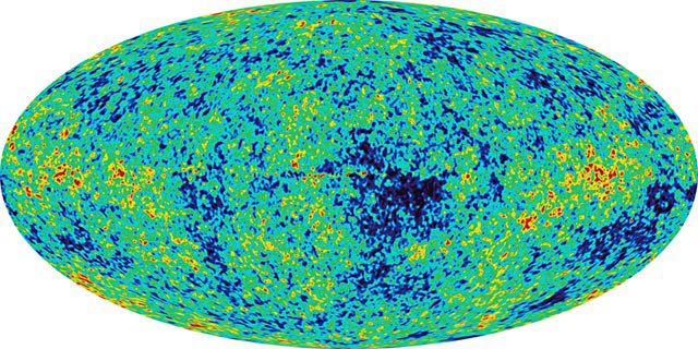
This is a map of the Universe at microwave frequencies with a temperature resolution of about a kelvin. The map is a projection of a sphere onto a flat plane, so this really represents the whole sky in coordinates where our Galaxy is along the horizon. The radiation is allmost of equal strength in all directions creating a smooth background. You can see the milky way as a brighter than the background strip running along the horizon.
If we turn up the contrast, so we look for fluctuations or devations from smoothness at finer and finer levels, we see that what originally looks smooth with bad temperature resolution starts to look a lot messier. You can clearly see clumps of hot matter and void of cold matter as the red and blue spots. This map has a temperature resolution of a few micro kelvin, or 10e-05 K or less. The Milky Way has been "removed" from this image for aesthetic purposes.

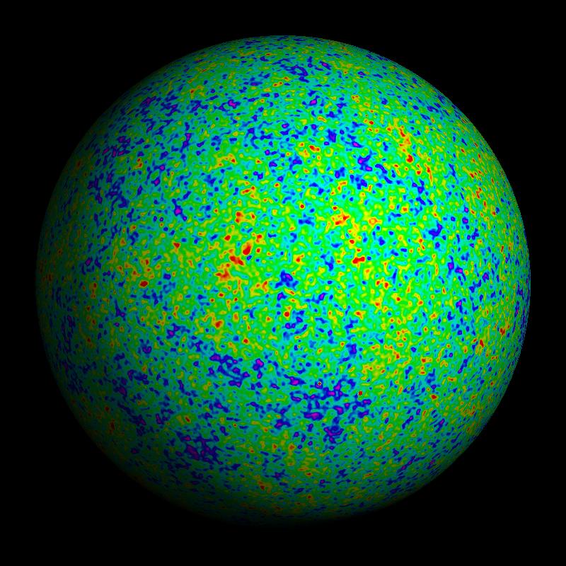
Another representation of the CMB clumpiness, this time as a true sphere, of course this way you cant see the whole sky at once.

So, its clumpy, that’s still not good enough?
The best feature of science is that it is never settled. The goal of science is to find natural evidence to support a hypothesis, or equally as important, to find natural evidence that contradicts a hypothesis. The CMB certainly supports the hypothesis, but that’s not enough. It never is. We could be wrong, even if not about the whole picture, possibly the details. There is more we can look for in the CMB, evidence that this is indeed radiation from gas in the early universe, not some other source we are mistaking it for. The clumps are good evidence of this, very good! Still, there is another piece of evidence that would help put the nail in the coffin, the polarization of the CMB.
Polarization is a little difficult to explain without an understanding of exactly what constitutes radiation. The basic idea is that every microwave we receive has an orientation to it. It’s kind of like a football. A football can be described by how fast it is going, what direction and which way the laces are facing. When you throw a good pass, the laces spin around as the ball spirals to the receiver. So, we will call the direction of the laces, the polarization. Radiation can come like a spiral pass, with the laces spinning around, or it can come with the laces just in one direction. It would be hard to throw a football so that the laces didn’t move, but radiation can be made to move this way.
Now every time radiation bounces off of something the direction of its polarization can change. If you have a lot of radiation, bouncing off of a lot of gas, the end result is that all of the radiation has different, or randomized polarization. If you dropped 100 footballs from a tower, with all the laces the same way, after they bounced the laces of each ball would point in completely random directions. Well, it turns out that some special situations can cause a lot of the radiation to line up, like a 25 of the 100 balls all having their laces face the same way after the bounce and the rest random. It turns out that this can happen to the CMB radiation as the universe expands early on, shortly after it is produced. Well, QUaD’s specialty is to figure out the direction of all the laces it gets and figure out if there is a pattern, like 25 out of 100 footballs. QUaD is a CMB polarization experiment.
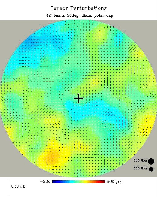
This is a zommed in view of the CMB clumps, but this time, the direction of the polarization has also been added. These are the sort of maps QUaD is trying to make.

Now, let me explain the name. QUaD stands for Quest and DASI. DASI is a very famous (among astrophysicists) CMB experiment. Their main focus was to get really detailed measurements of the clumpiness. Yet, they also managed to find that not only was the CMB clumpy, but it was also a bit polarized … just as predicted! Now the DASI experiment is finished, but it left behind a very well designed mount. A mount is what holds and moves the detector or receiver of the radiation. Quest is a new receiver that uses special sensors to detect radiation. In my next post, Ill have some pictures of the DASI mount and the Quest detector.
Why microwaves?
First, microwave radiation should be familiar to you if you have microwave oven. Microwave radiation is very similar to radio waves in frequency and wavelength, so you are even familiar in detecting them if you have ever had to adjust your radio to a certain station or move the antenna to get better reception. In fact, your cell phone uses microwaves in order to send or receive phone calls! Yet, cell phones, ovens and radio stations are not the only sources of this radiation. Nearly everything that has any energy gives off some radiation, and the hotter the object, the more and the more energetic the radiation. For example, your 100 degree Fahrenheit body (roughly 40 degrees Celsius) gives off quite a bit of infrared light (so red you can’t see it) while the Sun at roughly 6,000 degrees Celsius gives off yellow/green light. Well, you and the sun, the atmosphere and even the snowy ground here give off microwaves, which are “redder” than infrared light.
There are many reasons one might want to study microwave radiation. Stars, gas and dust in the Milky Way Galaxy give off plenty of microwaves. In fact, some galaxies like those with super-massive black holes in their centers, give off huge quantities of microwaves. QUaD isn’t interested in these astrophysical microwave sources. The source QUaD is interested in is the whole universe itself. These microwaves are the remaining radiation from the ancient universe. Big bang theory, the basis of modern cosmology or the history of the universe, claims that once the universe was very dense and hot and then expanded until now. That means everything was squished together much closer than now. When you squeeze something together, it heats up and 13 billion years ago the young universe was very hot indeed.
In fact it was so hot and dense that it wasn’t filled with stars and galaxies spread out like they are now but instead a thick gas, in some ways like the air you breathe (for analogy) spread out all over the place, everywhere. This hot gas that filled the whole universe shone very brightly. That light traveled through space and time and continues to do so now. Yet, as it traveled the universe also stretched out causing this hot bright radiation to “cool” down to microwaves. Now, since this is radiation that originated from a continuously spread out gas, it should be coming from everywhere at once. This is exactly what we see when we look out into space; in every direction we see the same microwave radiation all with the same temperature. This radiation fills the universe, like a bath, like a microwave oven. It passes through you and me and everything around us. The microwave radiation is commonly called the Cosmic Microwave Background (CMB). This is because it fills the universe and exists as a background temperature bath.
So, if the radiation is uniform and all around us, what else is there to learn?
Ok, the thing is that if the universe were once perfectly smooth, with no bumps and all at the same temperature, it wouldn’t ever clump up. If it was so smooth, there would be an equal pull from all directions on any patch of it and the net result would be that the patch wouldn’t go anywhere. Well, that’s obviously not true, there are tons of clumps all over the place. There are millions of stars in each galaxy, and billions of galaxies in the universe, and even the galaxies tend to clump up into groups. Where did all the clumps come from? Well, that’s a very difficult question to answer and the current answer lies in the theory of inflation, which I don’t want to talk about here and now. Inflation tells us a way to make the clumps. Inflation is a special case of universal expansion, one that last a very short time, is very intense and happened very early on in time.
So, if the clumps are there even in the early universe, then we should see clumpy parts that look a little hotter than less clumpy parts; remember the denser the hotter so clumpy parts will be hotter. This means that while the microwave radiation is mostly smooth and the same temp, if you look really carefully you should see some parts hotter than others. Well, guess what, we do. The CMB was discovered nearly 50 years ago, the clumpiness about 30, the details of the clumps were worked out by 10 years ago. Now, the CMB is some of our best evidence for big bang theory and universal expansion. Well, we can see the expansion of the universe by looking at galaxies; the CMB was a PREDICTION or CONSEQUENCE of expansion and big bang theory. Its discovery was a great affirmation.
This is a map of the Universe at microwave frequencies with a temperature resolution of about a kelvin. The map is a projection of a sphere onto a flat plane, so this really represents the whole sky in coordinates where our Galaxy is along the horizon. The radiation is allmost of equal strength in all directions creating a smooth background. You can see the milky way as a brighter than the background strip running along the horizon.

If we turn up the contrast, so we look for fluctuations or devations from smoothness at finer and finer levels, we see that what originally looks smooth with bad temperature resolution starts to look a lot messier. You can clearly see clumps of hot matter and void of cold matter as the red and blue spots. This map has a temperature resolution of a few micro kelvin, or 10e-05 K or less. The Milky Way has been "removed" from this image for aesthetic purposes.
Another representation of the CMB clumpiness, this time as a true sphere, of course this way you cant see the whole sky at once.
So, its clumpy, that’s still not good enough?
The best feature of science is that it is never settled. The goal of science is to find natural evidence to support a hypothesis, or equally as important, to find natural evidence that contradicts a hypothesis. The CMB certainly supports the hypothesis, but that’s not enough. It never is. We could be wrong, even if not about the whole picture, possibly the details. There is more we can look for in the CMB, evidence that this is indeed radiation from gas in the early universe, not some other source we are mistaking it for. The clumps are good evidence of this, very good! Still, there is another piece of evidence that would help put the nail in the coffin, the polarization of the CMB.
Polarization is a little difficult to explain without an understanding of exactly what constitutes radiation. The basic idea is that every microwave we receive has an orientation to it. It’s kind of like a football. A football can be described by how fast it is going, what direction and which way the laces are facing. When you throw a good pass, the laces spin around as the ball spirals to the receiver. So, we will call the direction of the laces, the polarization. Radiation can come like a spiral pass, with the laces spinning around, or it can come with the laces just in one direction. It would be hard to throw a football so that the laces didn’t move, but radiation can be made to move this way.
Now every time radiation bounces off of something the direction of its polarization can change. If you have a lot of radiation, bouncing off of a lot of gas, the end result is that all of the radiation has different, or randomized polarization. If you dropped 100 footballs from a tower, with all the laces the same way, after they bounced the laces of each ball would point in completely random directions. Well, it turns out that some special situations can cause a lot of the radiation to line up, like a 25 of the 100 balls all having their laces face the same way after the bounce and the rest random. It turns out that this can happen to the CMB radiation as the universe expands early on, shortly after it is produced. Well, QUaD’s specialty is to figure out the direction of all the laces it gets and figure out if there is a pattern, like 25 out of 100 footballs. QUaD is a CMB polarization experiment.
This is a zommed in view of the CMB clumps, but this time, the direction of the polarization has also been added. These are the sort of maps QUaD is trying to make.
Now, let me explain the name. QUaD stands for Quest and DASI. DASI is a very famous (among astrophysicists) CMB experiment. Their main focus was to get really detailed measurements of the clumpiness. Yet, they also managed to find that not only was the CMB clumpy, but it was also a bit polarized … just as predicted! Now the DASI experiment is finished, but it left behind a very well designed mount. A mount is what holds and moves the detector or receiver of the radiation. Quest is a new receiver that uses special sensors to detect radiation. In my next post, Ill have some pictures of the DASI mount and the Quest detector.
posted by Robert B. Friedman at 11:33 AM
0 comments
![]()
![]()